Hurricane Dorian remains a dangerous hurricane and is expected to move up the Southeast US coast today, approaching the North Carolina coast Thursday and Friday. There is still some uncertainty regarding the exact forecast track, but significant impacts are expected across eastern Virginia and Eastern North Carolina. Regardless, this is a very large system and impacts will be felt well away from the center.
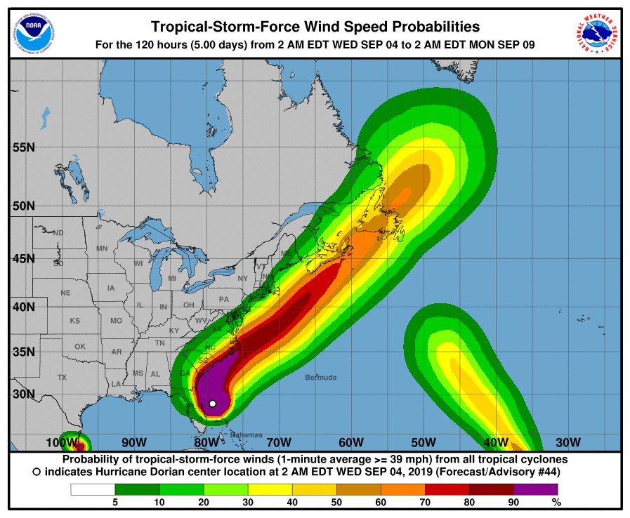
The strongest wind is expected late Thursday night into Friday across Northeast North Carolina and Eastern Virginia. Tropical storm force wind could develop as early as Thursday afternoon over Northeast North Carolina, with the wind peaking Friday morning into Friday afternoon. Hurricane force wind is possible, especially over coastal communities of Northeast North Carolina.
This strong wind will have the ability to knock down trees and weak structures, and cause power outages. Storm surge impacts are expected with Hurricane Dorian. Based on the current forecast, inundation of 2 to 3 feet above ground is possible from Hampton Roads into coastal Northeast North Carolina.
Even a small shift in the track could change what locations may see the most significant inundation.
Large breaking waves will likely result in moderate to significant beach erosion and ocean over-wash along the coasts of Southeast Virginia and Northeast North Carolina. Vulnerable areas could experience erosion at multiple high tide cycles. Very dangerous marine conditions are expected with seas 12 to 20 feet and potentially higher. A high threat of rip currents will continue for all area beaches and it is advised to stay out of the water.
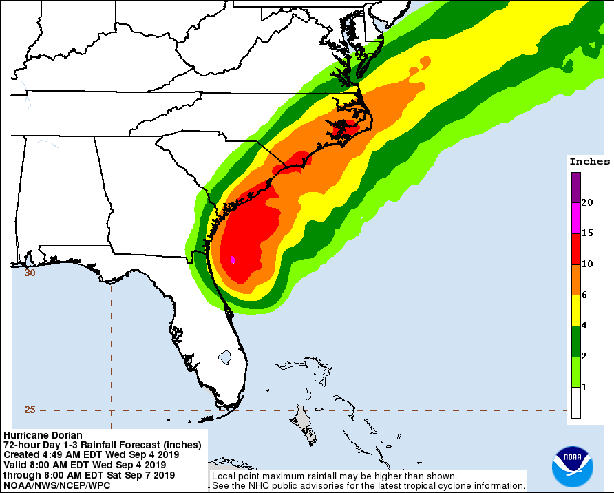
Hurricane Dorian will produce heavy rainfall across southeast Virginia and northeast North Carolina, with moderate impacts possible. The current forecast shows rainfall amounts ranging from 4 to 6 inches over southeast Virginia and northeast North Carolina, with up to 8 inches possible over northeast North Carolina. Rainfall amounts over the Virginia Eastern Shore are forecast to range from 3 to 5 inches. These heavy rainfall amounts in a relative short period of time has the potential to produce flash flooding Thursday night through Friday afternoon.
Small changes in the forecast could shift the heaviest axis of rainfall further inland or just off the coast, so continue to monitor the latest updates. Some minor to moderate river flooding is possible Friday and into the weekend, especially for smaller rivers and creeks.
POTENTIAL IMPACTS
-----------------

* FLOODING RAIN:
Prepare for dangerous rainfall flooding having possible significant
impacts across southeast Virginia and northeast North Carolina.
Potential impacts include:
- Flooding from heavy rainfall may prompt evacuations and rescues
- Rivers and tributaries may quickly become swollen, with swift
currents, and overspill their banks. Small streams, creeks, and
ditches overflow.
- Flood waters can enter some structures and/or weaken
foundations. Some areas may experience areas of rapid
inundation at underpasses, low-lying spots, and poor drainage
areas. Some streets and parking lots take on moving water as
storm drains and retention ponds overflow. Driving conditions
become hazardous. Some road and bridge closures are expected.
Prepare for locally hazardous rainfall flooding having possible
limited impacts across central and eastern Virginia.

* WIND:
Prepare for dangerous wind having possible significant impacts across
southeast Virginia and northeast North Carolina. Potential impacts in
this area include:
- Some damage to roofing and siding, along with damage to
porches, awnings, carports, and sheds. Some buildings
experience window, door, and garage door failures. Mobile homes
damaged, some destroyed, especially if poorly anchored or
exposed to wind. Unsecured lightweight objects become dangerous
projectiles.
- Large trees snapped or uprooted, especially in areas where
soils are saturated. Some roadway signs will be blown over.
- Some roads will be impassable from large debris including
bridges, causeways, and access routes.
- Scattered to widespread power and communications outages.
Also, prepare for hazardous wind having possible limited impacts
across central Virginia.

* SURGE:
Prepare for life-threatening surge having possible significant impacts
across northeast North Carolina and the Virginia Tidewater area.
Potential impacts in this area include:
- Severe storm surge flooding will likely cause inundation of
numerous roads and buildings, resulting in a threat to life and
property. Flooding will likely extend inland from the
waterfront and shoreline flooding homes, businesses and
isolating some neighborhoods. Large breaking waves will result
in additional damage near the shoreline.
- Numerous roads flooded or washed out.
- Major beach erosion with heavy surf breaching some dunes.
- Severe damage to marinas, docks, boardwalks, and piers is
expected. Small craft broken away from moorings, especially in
unprotected marinas and docks.

* TORNADOES:
Prepare for a tornado event having possible limited impacts across
northeast North Carolina. Potential impacts include:
- A few tornadoes are expected. As a result, execution of
emergency plans could be hindered in affected areas.
- A few places may experience tornado damage, along with power
and communications disruptions.
- Roofs peeled off some buildings. A few chimneys toppled and
mobile homes pushed off foundations or overturned. Large tree
tops and branches snapped off, with some trees knocked over. A
few vehicles blown off roads.
Elsewhere across CENTRAL AND EASTERN VIRGINIA...NORTHEAST NORTH
CAROLINA...AND THE LOWER MARYLAND EASTERN SHORE, little to no impact
is anticipated.
PRECAUTIONARY/PREPAREDNESS ACTIONS
----------------------------------

* EVACUATIONS:
Listen to local official for recommended preparedness actions,
including possible evacuation. If ordered to evacuate, do so
immediately.
For those not under evacuation orders, assess the risk from wind,
falling trees, and flooding at your location. If you decide to move,
relocate to a safer location nearby. If you do not relocate, help keep
roadways open for those under evacuation orders.
If evacuating, leave with a destination in mind and allow extra time
to get there. Take your emergency supplies kit. Gas up your vehicle
ahead of time.
Let others know where you are going prior to departure. Secure loose
items and pets in the car, and avoid distracted driving.
If evacuating, follow designated evacuation routes. Seek traffic
information on roadway signs, the radio, and from official sources.

* OTHER PREPAREDNESS INFORMATION:
Now is the time to check your emergency plan and emergency supplies
kit and take necessary actions to protect your family and secure your
home or business.
When making safety and preparedness decisions, do not focus on the
exact forecast track since hazards such as flooding rain, damaging
wind gusts, storm surge, and tornadoes extend well away from the
center of the storm.
If in a place that is vulnerable to high wind, such as near large
trees, a manufactured home, upper floors of a high-rise building, or
on a boat, plan to move to safe shelter.
If you live in a place particularly vulnerable to flooding, such as
near the ocean or a large inland lake, in a low-lying or poor
drainage area, in a valley, or near an already swollen river, plan to
move to safe shelter on higher ground.
Always heed the advice of local officials and comply with orders that
are issued. Do not needlessly jeopardize your life or the lives of
others.
When securing your property, outside preparations should be concluded
as soon as possible before conditions deteriorate. The onset of
strong gusty winds or flooding can cause certain preparedness
activities to become unsafe.
Be sure to let friends and family members know of your intentions for
weathering the storm and your whereabouts. Have someone located away
from the threatened area serve as your point of contact. Share vital
contact information with others. Keep cell phones handy and charged.
Check on those who may not be fully aware of the situation or who are
unable to make personal preparations.
If you are a visitor, know the name of the county in which you are
located and where it is relative to current watches and warnings. If
staying at a hotel, ask the management staff about their onsite
disaster plan. Listen for evacuation orders, especially pertaining to
area visitors.
Closely monitor weather.gov, NOAA Weather Radio and local news
outlets for official storm information. Listen for possible changes
to the forecast.
There is a threat from tornadoes with this storm. Have multiple ways
to receive Tornado Warnings. Be ready to shelter quickly.

* ADDITIONAL SOURCES OF INFORMATION:
- For information on appropriate preparations see
www.readyvirginia.gov, readync.org or mema.maryland.gov
- For the latest weather and storm information go to
weather.gov/wakefield.